
 MetroPlan Orlando plans, supports, and advances the region’s network of Complete Streets. Complete Streets are planned, designed, constructed, operated, and maintained to safely and comfortably accommodate people of all ages and abilities. That includes, but is not limited to: pedestrians, cyclists, scooter riders, transit users, rideshare users, motorists, and freight and service operators.
Benefits of Complete Streets
Complete Streets help make a livable community for everyone. There are a wide variety of benefits, including:
- Improved safety,
- Better access, particularly for people with disabilities,
- Economic development throughout the area,
- Enhanced public health through active transportation, and
- Improved air quality for a better environment.
Our REGIONAL complete streets POLICY
In addition to supporting municipal Complete Streets policies across our region, we have spent the past several years developing a regional Complete Streets policy to guide the planning and design of Central Florida’s transportation network. Our goal is to create livable communities that provide safe, convenient transportation such as walking, bicycling and public transit, in addition to driving and so we wanted to create a policy that reflected that vision.
In March 2020, the MetroPlan Orlando Board approved the Regional Complete Streets Policy. This policy will help shape the future of the region by ensuring that all future roads and improvements are consistent with Complete Street guidelines. The policy was written with best practices in mind and with the help of our local government partners.
MetroPlan Orlando Regional Complete Streets Policy – Approved 3-11-20
In 2016, MetroPlan Orlando and its partners made the case for Complete Streets in its Complete Streets Policy Report. The report explained how the Complete Streets approach would benefit Central Florida.
Complete Streets Draft Policy Report – 2016
COMPLETE STREETS IN THE 2045 PLAN
Complete Streets play an important role in achieving the goals we laid out in the 2045 Metropolitan Transportation Plan. Those goals are: 1) Safety & Security; 2) Reliability & Performance; 3) Access & Connectivity; 4) Health & Environment; and 5) Investment & Economy.
Our 2045 Plan allocates 32% of MetroPlan Orlando’s Transportation Management Area (TMA) funds to Complete Streets projects. Over the course of the next 25 years, that amounts to over $203 million spread across 21 projects. Visit the 2045 Metropolitan Transportation Plan page for more information.
PAST COMPLETE STREETS STUDIES
Click on the buttons below to jump to a specific past study:
Rock Springs Road in Apopka West Orange Trail Extension 10th Street in St. Cloud Silver Star Road in Ocoee Corrine Drive in Orlando Case Studies
Rock Springs Road in Apopka
The Rock Springs Road Study in Apopka evaluated safety and access improvements at the intersection of Rock Springs Road and Welch Road, and along the half-mile of Rock Springs Road from Welch Road to Lester Road. The study also included an intersection analysis and evaluation of realignment for the intersection of Sandpiper Street with Park Avenue. MetroPlan Orlando led the effort in 2021-2022 in coordination with the City of Apopka, Orange County, and other local stakeholders. Alternatives were developed, analyzed, and shared with the public and local agencies for input to develop a Recommended Alternative. For more information, view a fly over video of the recommended concept and read the final report below. Additional study documentation is available upon request by contacting MetroPlan Orlando at info@metroplanorlando.gov.
Rock Springs Road Corridor Study Final Report
Rock Springs Road Executive Summary Final Report
Rock Springs Road Final Report Appendices
West Orange Trail Extension in Apopka
The West Orange Trail Extension study in Apopka was completed in 2021-2022 by MetroPlan Orlando in conjunction with the City of Apopka, Orange County, FDEP, representatives of the Wekiwa Springs State Park, and other local stakeholders. The study evaluated three areas to connect the existing West Orange Trail to community centers, respectively: along Rock Springs Road from Lester Road to Kelly Park Road, tying into the proposed Wekiva Trail; along Welch Road and Wekiva Springs Road from Rock Springs Road to the existing Wekiwa Springs State Park entrance, and along Ponkan Road from Rock Springs Road to the Wolf Lake Elementary and Middle Schools. Trail alternatives were developed, analyzed, and shared with the public and local agencies for input to develop a Recommended Alternative for each of the above-mentioned sections of the project. For more information, view a fly over video of the recommended design and read the final report below. Additional study documentation is available upon request by contacting MetroPlan Orlando at info@metroplanorlando.gov.
West Orange Trail Corridor Study Final Report
West Orange Trail Executive Summary Final Report
West Orange Trail Final Report Appendices
10th Street in St. Cloud
The 10th Street Complete Streets Study in St. Cloud evaluated 10th Street from US 192 to South Narcoossee Road. MetroPlan Orlando led the effort in 2021-2022 in coordination with the City of St. Cloud, Osceola County, and other local stakeholders. The study aimed to improve transportation and safety for residents and visitors, creating a positive economic impact to the community. Following an extensive technical evaluation and public participation process, a concept plan was developed using input from hundreds of members of the community. For more information, view a video of the 10th Street recommended design on our YouTube channel here or read the final report below. Additional study documentation is available upon request by contacting MetroPlan Orlando at info@metroplanorlando.gov.
10th Street Study – Final Report – June 2022
Silver Star Road in Ocoee
The Silver Star Road Complete Streets study examined a lower cost alternative to widening with improved safety, and extension of the West Orange Trail to Downtown Ocoee. MetroPlan Orlando led the study, working directly with City of Ocoee to develop recommendations that support the overall Downtown Vision while maintaining a safe and reliable connection to SR 429 and destinations to the east. For more information, read the final report below. Additional study documentation is available upon request by contacting MetroPlan Orlando at info@metroplanorlando.gov.
Silver Star Road Complete Streets Study – Final Report – July 2019
Corrine Drive in Orlando
A study looking at Corrine Drive, from US 17/92 to Bennett Road, used MetroPlan Orlando’s 2015 Draft Complete Streets Policy to showcase how Complete Streets techniques can shape a corridor. MetroPlan Orlando led the Corrine Drive Complete Streets study in coordination with Orange County, City of Orlando, and City of Winter Park. For more information, view a video of the Corrine Drive recommended design on our YouTube page here or read the final report below. Additional study documentation is available upon request by contacting MetroPlan Orlando at info@metroplanorlando.gov.
Corrine Drive Complete Streets Study – Final Report – April 2019
Case Studies
As part of the policy development process, MetroPlan Orlando conducted a series of regional case studies to highlight strategies for incorporating Complete Streets design principles into local projects. Each case study corridor was selected to show specific teachable elements of Complete Streets design and implementation. See the reports below for more information. The corridors are:
- Columbia Avenue (Kissimmee) – Enhanced bicycle and pedestrian accommodations to support future transit investment
- Howell Branch Road (Seminole County) – Improve bicycle and pedestrian comfort and safety on large suburban arterial
- Orange Center Boulevard (Orlando) – Lane reduction and enhanced bicycle accommodations to support community redevelopment
Additional study documentation is available upon request by contacting MetroPlan Orlando at info@metroplanorlando.gov.
Columbia Avenue Complete Streets Case Study
Howell Branch Road Complete Streets Case Study
Orange Center Complete Streets Case Study
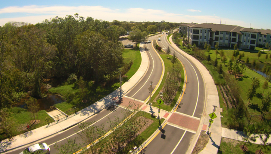
Complete Street improvements on North Oxford Road include dedicated bicycle lanes, 8-foot sidewalks and enhanced pedestrian crossings. (Photo courtesy of City of Casselberry)